Dunbar Seafield
Saturday 26th August 2017

Our August event was at Dunbar in our regular slot of the last Saturday of the month. It was be based at the Seafield area of Belhaven and courses were planned by Godfrey Beddard.
Results
Advance information:
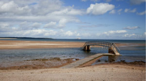 There will be a range of courses. The shorter courses stay within the shore area and adjacent caravan park but the Orange and GreenT courses include some technical legs across the estuary on ‘Spike Island’ (i.e. the sand dunes running west from Belhaven Bay) and therefore are subject to the tide; also, GreenT has specific Start / Finish times…
- White / Yellow / Orange – Starts from 13:00 until 15:00 – courses close at 16:30
- GreenT – Starts from 13:00 until 14:30 – course closes at 16:30.
For something different (and hopefully interesting!) the GreenT course uses a special training version of the Spike Island map with contour detail, but with no paths marked although we have also printed copies of the courses with the (confusing) paths included. You can choose which to take.
Final Details
Type of event
Type of terrain
Other Users
Dogs
Location
Nearest town: Dunbar
Grid Ref: NT663786
Postcode: EH42 1NU
Parking
Registration & Start Times
Registration
Facilities
Start and Finish
Courses Close
Course Information
Map
Courses
- White (very easy) 1.7 km – 1:5000 map
- Yellow (easy) 1.8 km – 1:5000 map
- Orange (moderate) 3.1 km – 1:5000 map
- Green & GreenT (Green Training) (hard) 5.2 km – 1:7500 map
There is very little climb on any course.
Timing
Planner
Godfrey Beddard
Entry Charges
- Seniors (born 1995 or earlier)
British Orienteering members – £3
Non-members – £5 - Juniors (born 1996 or later)
British Orienteering members – £1.50
Non-members – £2.50 - Groups (Adults + children)
Each additional adult in a group: add £1 - Each additional junior in a group: add 50p
Safety and Risk
Privacy
When entering our events your name may appear in the results section of this website or in newspaper reports.