Hartside Hill SOL
Sunday 7 September 2025

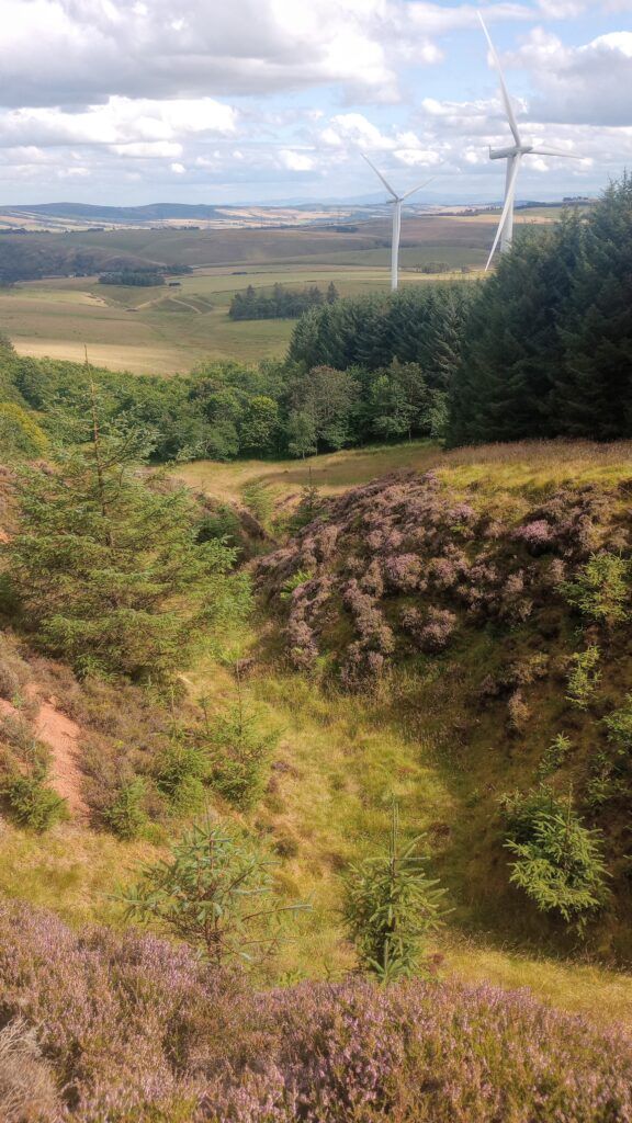
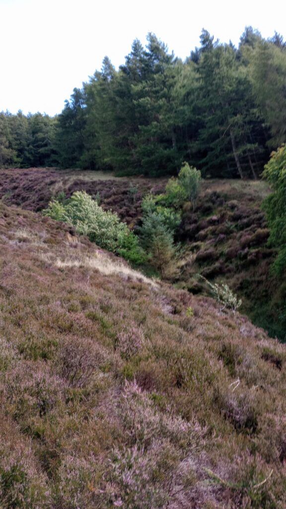
Hartside Hill is a new area for orienteering, near Soutra Pass, just off the A68. It is an extensive plantation woodland with deep cleughs, rides of varying widths and an extensive ditch network.
We are grateful to David Smith and Bidwells for permission to use the forest and to the Duns, who farm at Gilston, for parking. Parking is likely to be tight so we would encourage people to meet at Pathhead and car share where possible.
Orienteers of all abilities are welcome to join us for this Scottish Orienteering League event where there will be a range of courses to suit everyone.
Planner’s Report
It was mostly a pleasure to be out in a new forest planning how best to use the area. There were restrictions based on planned felling in the eastern section of the forest which meant that the courses had to start east of the powerlines and head up the hill.
The narrower rides and ditches were the fastest running followed by the white forest once broken into through the edges and so the courses were planned to try to encourage using those. It was easy to get drawn down the planting lines which tended to veer away from the direct routes to controls and a good bearing was required to hit some of the controls while minimising one’s aiming off.
Sorry about the additional ditch that some folks found as they headed towards the finish! Hopefully it didn’t detract from an area which isn’t like many others near to Edinburgh. With a bit of luck the plan to clear fell the area over the next 10 years will progress quite slowly.
Results
- Simple results are here.
- Routegadget allows you to plot your route, either by hand or by downloading a gpx file from a watch or phone and to look where you and others went.
- Winsplits Online gives another way of comparing your times for each leg.
- British Orienteering collect results from all events and publish ranking scores for larger events.
Type of event:
Scottish Orienteering League Event
Terrain:
- Hartside Hill is a plantation forest. Some of the blocks of wood are thick to break into but once in the running is generally good although there are many low-level branches so care should be exercised. The thickest areas to break through into runnable forest are indicated on the map. Full leg and body cover is mandatory and arm cover is strongly advised.
- Visibility is generally good and the underfoot conditions are stable but in wet weather the woods can be dark because of the thick canopy.
- The more open areas and wider rides are either heather-covered or marshland (which is relatively dry just now) but courses are designed to minimise lengthy runs along the heaviest-going of these areas. A vertical green screen has been applied to show the heather-covered rides.
- The network of ditches and rides is extensive, particularly at the higher points of the woodland. Because of the dry weather the ditches are mostly free of water. Mapped ditches are >50cm in depth within the woodland – they are useful and clear for navigation.
- Forestry work is ongoing but courses have been designed to avoid the notified areas of felling. You are reminded not to touch any log piles or forestry equipment which you may see.
- Most of the blocks of woodland are flattish but on an incline so accurate compass work will be required to hit features economically. Unusually for southern Scotland, there are very few brambles.
- The Orange and Yellow courses are longer than usual to ensure the correct technical difficulty but the majority of these courses take competitors downhill.
- Both the Yellow and White courses contain taped routes which will be marked with strips of White tape. An example of the style of taping will be visible between registration and the gate into the forest.
Other Users
The area is not regularly used by the general public so you are unlikely to meet other people. For this reason we would strongly advise you to take a whistle.
Dogs
Because the parking area is used for cattle, dogs are not permitted.
Toilets:
Toilets will be available near the exit from parking.
Accessibility:
The courses all contain sections which cover rough open ground – both white and yellow courses include taped routes through the woods and/or across heather. You may prefer to shadow younger competitors on white and yellow following your own run.
Location
Nearest Town: Pathhead, Midlothian
Grid Ref: NT444566
Nearest Postcode: EH37 5TF
Directions
Follow the A68 south from Edinburgh. After joining other orienteers at Pathhead continue to head south on the A68. As you start to ascend towards Soutra pass, turn right along the B6368 following the sign to Soutra Aisle. The event is 2 miles south along the B6368.
Public Transport
The nearest train station is at Stow from which the event is 10 mile cycle.
Borders Bus #51 from Edinburgh stops at the North end of the B6368, 2 miles from the event – unfortunately bikes are not currently able to be taken on this service.
Nearest Defibrillator:
Registration
Registration & Start Times
Registration
This will be online (and for newcomers near the entrance to the woods) – look for the ELO flag and tent!
Please request an early start time if you think you might take a long time to complete your course.
Start and Finish:
Start times will be from 12:00 to 2:00pm.
The Start is a 1.7km walk with 50m of climb from the parking. The finish is 400m from the parking.
Courses Close:
The courses will close at 4:00pm so it is essential that you report to the Finish by then, even if you have not completed your course.
Course Information
Map
The map is printed at 1:15,000 for Black and Brown courses & 1:10,000 for all other courses. with 5m contours.
Timing
SportIdent (SI) electronic timing will be used – we will have SIs for hire free of charge but there is a £30 charge if lost. Units, apart from start and finish, will be set for contactless punching.
Courses
There will be Black, Brown, Short Brown, Blue, Short Blue, Green, Short Green, Very Short Green, Light Green, Long Orange / Red, Orange, Yellow and White courses.
| Course | Length / Ascent | Description |
|---|---|---|
| Black | 10.5km / | Very challenging navigation including route choice and rougher terrain away from paths. |
| Brown | 8.2km / | Very challenging navigation including route choice and rougher terrain away from paths. |
| Short Brown | 7.7km / | Very challenging navigation including route choice and rougher terrain away from paths. |
| Blue | 5.8km / | Very challenging navigation including route choice and rougher terrain away from paths. |
| Short Blue | 4.9km / | Very challenging navigation including route choice and rougher terrain away from paths. |
| Green | 4.6km / | Very challenging navigation including route choice and rougher terrain away from paths. |
| Short Green | 3.6km / | Very challenging navigation including route choice and rougher terrain away from paths. |
| Very Short Green | 3.1km / | Very challenging navigation including route choice and rougher terrain away from paths. |
| Light Green | 3.2km / | For more experienced orienteers. More challenging navigation including route choice and rougher terrain. |
| Long Orange / Red | 4.7km / 130m | For adult who enjoy more running than navigating. Controls near paths or line features. |
| Orange | 3.8km / 120m | Controls near paths or line features. |
| Yellow | 3.1km / 85m | Follows line features with controls after choice points. A longer than usual course so that it sticks to paths and rides. |
| White | 1.6km / 25m | Follows paths with a control at each choice point. |
More details about the colour coding is available on the Scottish Orienteering website.
Organiser:
Jamie WIlson & Michael Atkinson
Planner:
Michael Atkinson
Controller:
Roger Scrutton (ESOC)
Other Information:
White and Yellow maps must be collected at registration.
A table showing how the colours match to age classes for the Scottish Orienteering League can be found on the SOA website.
Entry Charges
Entry is cheaper if you are a current 2025 member of a club affiliated to Scottish or British Orienteering.
Please ensure that your membership has been renewed for 2025.
| Entry Type | British Orienteering member | Scottish Orienteering member | Non‑member | Late Entry |
|---|---|---|---|---|
| Seniors | £12 | £13 | £14 | +£2 |
| Juniors | £4 | £5 | £6 | +£1 |
| Pair of Seniors | £14 | £15 | £16 | +£2 |
| Pair of Juniors (no accompanying adults) | £5.50 | £6.50 | £7.50 | +£1 |
| Junior and Parent | £7 | £8 | £9 | +£1 |
| Family Groups (one or more children accompanied by one or more adults) | £10 | £11 | £12 | +£1 |
Safety and Risk
A comprehensive risk assessment has been carried out by the organisers, but participants take part at their own risk and are responsible for their own safety during the event
Medical Conditions:
If you, or anyone in your group (including juniors), have a medical condition that first-aiders or health professionals should know about in the event of accident or illness during the course of the event please print off the Medical Form, complete it fully and bring it along to the event. You should complete a separate copy for each individual who has a medical condition. Please leave the completed Medical Form at Event Registration. If it is not in a labelled sealed envelope, it will be put in one and will be opened only in an emergency. It will be shredded immediately after the event if you do not claim it back.
Privacy
When entering our events your name will appear in the results section of this website and may appear in newspaper reports.
We may also take photographs at the event for publicity purposes – please let us know if you do not want us to use your photograph in this way.
Read our privacy policy.