Gosford Estate
Saturday 28th April 2018

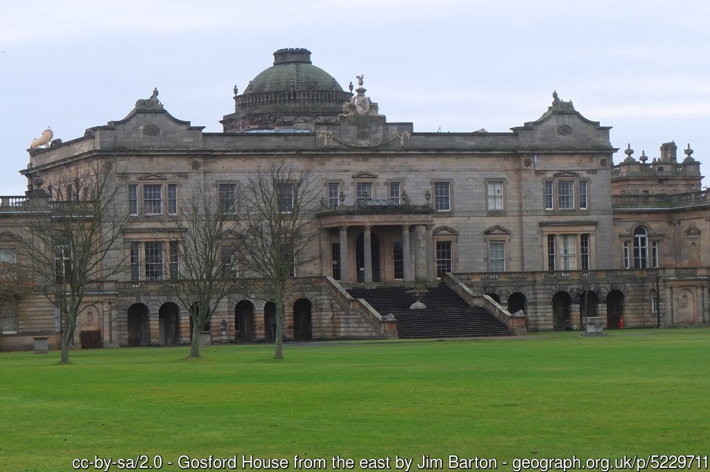
Gosford House, East Lothian. Photo Credit: Jim Barton - geograph.org.uk/p/5229711
Results
Saturday afternoon saw us at a brand new area for orienteering in East Lothian: Gosford Estate.
Many thanks to all the many competitors and helpers who came and especially to Tim Harding for planning the courses. Although the area is quite large it is tough for the planner to avoid the many OOB areas and impassable barriers – those two metre ha-has – but Tim found a full range of technical difficulty.
Planner’s Comments:
Thank you to everyone for coming, and to everyone who helped. Sorry we ran out of Green maps so early — we were too humble when deciding numbers. Guiding people around all those obstacles ate up a lot of controls, and I wanted the Green to get into the Limekiln and Barr Moon strips, and that used even more — apologies to those Green runners champing at the bit while I was still setting out the last few!
It was interesting seeing how rapidly the terrain changed during the month or so I was planning: when I began, there was no vegetation on the ground, no leaves on the trees — so sightlines were much longer — and the wide ditches were seriously full, quite hazardous. At one point, the area round the ponds was closed to the public, because of waterlogging, which would have killed the event. It was a big relief when it re-opened, as I think if we’d had to postpone even a week, the vegetation would have changed the dynamics of the courses.
I’d particularly like to thank Pat Blashill from Stirling Surveys for his mapping, and for going the extra mile (kilometre!) to get every detail right.
Gosford is a privately-owned estate stretching between the East Lothian villages of Longniddry and Aberlady. The area contains 18th-Century Gosford House and its park in the centre, sections of farmland, and surrounding deciduous woodland. Although the event stayed away from the House itself (which was not open on the day), the parkland contains many interesting features such as ornamental ponds, ha-has, a mausoleum, a grotto, and an ex-POW camp!
Gosford House, East LothianGeneral Information
Type of event:
Local event in the East of Scotland Orienteering Association (ESOA) series
Type of terrain:
This particular event will use the eastern half of our new map, which boasts only a few contour features, but has a complex network of paths and ditches in the northern part, and more traditional mixed woodland elsewhere.
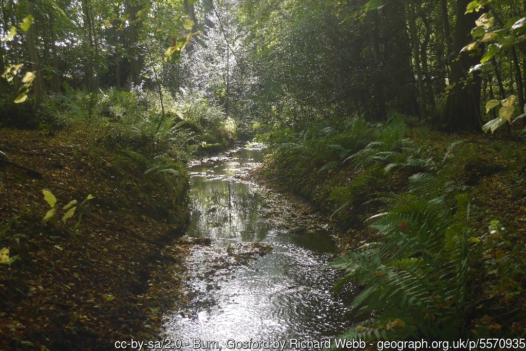
This photograph was taken in the summertime — there’s no bracken at the moment!
The woods are quite runnable at this time of year. A few nettles are just beginning to show, and some of the more open areas have scattered small brambles (the courses try to avoid these). The ground was quite muddy underfoot during the wet weather, but is now drying out rapidly.
Other Users:
There are several private dwellings on the Estate, and a wedding is taking place in the House itself on the day of our event.
Please observe all out-of-bounds areas strictly, throughout the day.
Dogs:
Dogs must be on leads.
Be aware that the usual East Lothian wildlife (deer and hares) are common.
See also the note about blue-green “algae”, which can be toxic to dogs.
Toilets:
Nearest toilets are at Gosford Farm Bothy Shop.
Location
Nearest town: Aberlady
Grid Reference: NT 453 782
Postcode: EH32 0PX
Directions:
We are parking near the location below, with entry through the nearby gate from the A198, 1km south of the North Lodge (which is the “official” entrance to Gosford House).
It is also possible to get to the event by bus (Edinburgh-North Berwick service from East Coast Buses; use the “Pleasance” stop in Aberlady, then close your eyes when walking from the Bothy to assembly!) or by train to Longniddry (enter by the West Lodge gate for a pleasant 3km walk through the woods in the southern part of the Estate).
To make a day of it, the excellent Gosford Bothy Farm Shop and Café is a 1km walk from assembly (although that walk will take you through the competition area, so if you visit the cafe before your run, you might want to go round by road instead; you may also wish to know that last food orders are at 3:30pm sharp!)
Registration & Start Times
Registration:
This will be from 1:45pm to 3:00pm.
Pre-entry is not available, all entries will be taken on the day.
You can download and complete the registration form and bring it with you.
Please try to register and start early if you think you might take a long time to complete your course.
Start and Finish:
The start and finish will be close to registration.
Start times will be from 2:00pm to 3:00pm.
Courses Close:
The courses will close at 4:00pm, so if you have not completed your course by then, you should stop and return to assembly. You must report to the Download point, whether you complete the course or not, so that we know you are not lost or injured in the woods!
Course Information
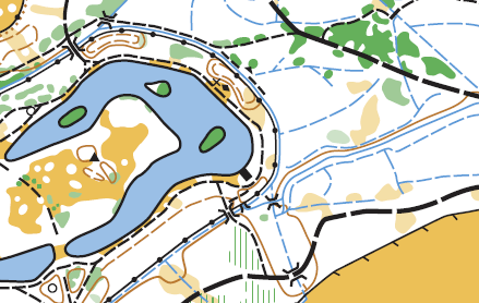
A sample of the Gosford Estate map
Map:
The map has recently been completed by Stirling Surveys and will be printed at varying scales depending on the course (see the table below). All maps have 2.5m contours.
A few notes on the mapping:
- Ditches: although they are all technically crossable as mapped, you probably won’t want to choose routes that cross the ditches shown as continuous lines, as they are quite wide, with steep sides, and may be a bit deep after rain. The ones shown as broken lines are in general fairly easily crossed. In any case, courses are planned so that you shouldn’t need to cross many, or perhaps any, of them except via bridges.
- Vegetation:
- The rhododendrons have grown a little since some areas were first mapped.
- There is windfall, here and there, which is not shown.
- Not every holly bush is on the map!
Timing:
SportIdent (SI) electronic timing will be used – we will have SIs for hire free of charge but there is a £30 charge if lost.
Courses:
There will be White, Yellow, Orange, Light Green and “Green” courses. Course lengths (all with negligible climb) are as follows…
| Course | Length | Difficulty | Map Scale |
|---|---|---|---|
| White | 1.2 km | Very easy | 1:5000 |
| Yellow | 2.2 km | Easy | 1:5000 |
| Orange | 2.5 km | Medium | 1:5000 |
| Light Green | 3.9 km | Medium to Hard | 1:7500 |
| Green | 5.4 km | Hard | 1:10000 |
Although the “Green” course is an extended version of the Light Green, and is not true TD5, the extension visits a (more distant) area that none of the other courses go into, with slightly trickier controls.
More details about the colour coding is available on the Scottish Orienteering website.
Entry Charges
- Seniors
- British/Scottish Orienteering members – £3
- Non-members – £5
- Juniors
- British/Scottish Orienteering members – £1.50
- Non-members – £2.50
- Groups (Adults + children)
- Each additional adult in a group: add £1
- Each additional Junior in a group: add 50p
Safety and Risk
A comprehensive risk assessment has been carried out by the organiser, but participants take part at their own risk and are responsible for their own safety during the event.
All courses run very close to water features of various kinds (ponds, ditches): it is impossible to avoid these and still have sensible courses, so please be aware of this when deciding whether to accompany juniors or not. Other potential hazards (which the courses aim to mitigate where possible, especially for the juniors) include:
- A number of high sunken walls (“ha-has”), are up to two metres high from one side, and are almost invisible from the other. Some of these have water at the foot. They are all marked uncrossable.
- Piles of logs – please remind young folk not to climb on them.
- Blue-green algae is present in the ponds, which can be toxic.
- All courses make some use of estate tracks. During planning visits, the planner reports seeing a vehicle only once, and sight-lines are good, but it is possible even juniors might encounter a car or van.
- Stone monuments – please remind juniors not to push or lean on them.
- There are a few geese living on the ponds – please remind youngsters not to approach them.
- There are wooden bridges which may be wet if it rains.
- There are some abandoned farm buildings just outside the event area.
- There are a couple of electric fences in the area (but you would have to go out of your way to touch them).
A couple of standard advisories:
- As there are deer and other wildlife in the area, please wash your hands before eating, and check for ticks after running.
- There may be dog-walkers whose dogs are not as well-controlled as they should be, and junior runners should be advised accordingly.
Medical Conditions:
If you, or anyone in your group (including juniors), have a medical condition that first-aiders or health professionals should know about in the event of accident or illness during the course of the event please print off the Medical Form, complete it fully and bring it along to the event. You should complete a separate copy for each individual who has a medical condition. Please leave the completed Medical Form at Event Registration. If it is not in a labelled sealed envelope, it will be put in one and will be opened only in an emergency. It will be shredded immediately after the event if you do not claim it back.
Privacy
When entering our events your name may appear in the results section of this website or in newspaper reports.
Acknowledgements
Many thanks to Wemyss and March Estates for granting us the opportunity to map and run in this area.