North Berwick Sprintelope
Wednesday 28th June 2023

Sprintelopes are lightweight informal events featuring Urban style races around the streets of towns in East Lothian and other areas in and around Edinburgh on Wednesday evenings.
In 2023, ELO are contributing six races to the series – this is the sixth of them, around North Berwick!
Orienteers of all abilities are welcome to join us on the day when we will have a range of courses to suit everyone including under 16s who have a course with no road crossings.
Event Report
Thanks for coming along to the final ELO-organised Sprintelope of the season. I am very grateful to all the planners who have contributed to the series – Robin Strain, Jamie Wilson, Duncan Leishman, Simon Fairfull, David Robertson, and Tim Harding – without planners there would be no courses to run around. It was good to see junior courses at a few of the events and we hope to continue that next year.
Special thanks go to Robin and Sheila Strain for their support with all things SI and logistics – without them there would most certainly be no results.
We hope you enjoyed the series and we look forward to seeing you at some of the other clubs’ sprintelopes soon.
Results
- Simple results are here.
- Routegadget allows you to plot your route, either by hand or by downloading a gpx file from a watch or phone and to look where you and others went.
- British Orienteering collect results from all events and publish ranking scores for larger events.
- Munroleagues compile the Sprintelope series results.
General Information
Type of event:
Local event in the summer Sprintelope series.
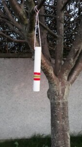
Because they are informal, there are typically only SI units for the start and finish – the rest of the controls are usually drainpipes (which are less conspicuous than flags)!
There will be a long (5km) and a short (3.5km) option although these are straight line distances so expect to run further than that.
Because of the road crossings ALL under 16s must be accompanied at all times by an adult when running.
Notes:
- The quickest way to walk from the station is to exit by the side gate (half-way along the platform) and walk up the footpath to the Ware Road bridge over the railway. Cross the bridge and two roads (carefully), and you will be at the entrance to the park where assembly is located (total distance 350m). If coming by bus, get off just after the Nether Abbey Hotel, and walk up Ware Road to the same railway bridge (total distance 500m).
- Parking is along Glenorchy Road.
- Shorts and flat soles will be fine, but if it has been raining (which currently looks likely!), you will benefit from a bit of grip on the grassed areas and the paths through the woods.
- On the Long and Short courses, there is a timed-out crossing over the railway bridge (used twice, once in each direction). The bridge is narrow, carries vehicle traffic as well as pedestrians, and has pedestrian-controlled traffic lights. On arriving at the bridge, please dib the unit, press the button on the pedestrian crossing, cross when safe, and dib the unit on the other side. The timeout will be set at “unlimited” so you will have as much time as you need!
- Please observe do-not-enter areas. For example, in the northern part of the map, viable routes include footpaths that cross private lawns (which are mapped in olive green). Please stick to the paths if you choose these routes.
- There are many individual trees and thickets in the area, but almost none of them are mapped.
- There is a wooded area used by the Long and Short courses. No vegetation detail in this wood is mapped: it is all marked “fight”. It may also contain unmapped indistinct paths. Please stick to the mapped paths.
- Please observe any out-of-bounds areas.
Other Users
The area is very well used by the general public including dog walkers and families. Please respect their right to be there at the same time as you are orienteering.
Dogs
The area is well used by dog walkers so dogs are welcome to come with orienteers.
Toilets:
Toilets are at the Sports Centre (Grange Road) or the centre of town (Quality Street).
Accessibility:
Generally speaking, level paved routes exist between all controls. However:
- The shortest route choice for some legs is not always completely step-free and paved (it may involve areas of grass, unpaved paths, steps, etc.) and finding a step-free paved route will be longer.
- The surface of some paved areas is a little uneven, and there may be low kerbs to descend or ascend, or small detours to find a dropped kerb.
- Some controls cannot be reached entirely via a step-free paved route, in the sense that the final few metres involve grass, an unpaved path, steps, etc. (but bear in mind that the controls are not dibbable anyway!)
- Some gates/paths may be a little tight to negotiate (roughly a metre wide).
- There may be unmapped steps.
What to Expect
Sprintelopes are informal events and as such there is no electronic punching at most of the controls.
It’s taken on trust that you visit them and instead of looking for a large white and orange kite you are looking for a more discreet white drainpipe which is usually hung on a tree, a drainpipe, a fence etc…
Normally, the only time you need to “dib” a control is at the start and the finish to record your total time. At this event, Long and Short course runners should also punch units at each side of a narrow bridge.
At the start there is an all-in-one board to clear, start and then indicate whether you are running the short or the long course.
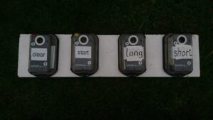
After you’ve punched the long or short option its time to find the rest of the controls (but don’t try to stick your dibber into them as they won’t beep) and enjoy yourself.
You MUST report back to the finish and download even if you don’t manage to find all the controls so that we don’t go out hunting for you!
Location
Nearest Town: North Berwick
Grid Ref: NT545848
Nearest Postcode: EH39 4QD
Directions
Parking on Glenorchy Road with the start/finish in the small park just to the South.
Public Transport
It’s a 4 min (300m) walk from the station and about a 5 minute walk from the bus stops.
Registration & Start Times
Registration
This will be in advance online – look out for the ELO flag on the day!
Please select an early start time if you think you might take a long time to complete your course.
Start and Finish:
Start times will be from 6:00pm to 7:00pm.
The Start and Finish locations are in the small park to the south of Glenorchy Road.
Courses Close:
The courses will close at 8:00pm, so if you have not completed your course by then, you should stop and must return to assembly.
Controls in the first half of the course will be brought in from 7:30pm.
You must report to the Download point, whether you complete the course or not, so that we know you are not lost or injured in the town!
Course Information
Map
The map is printed at 1:5000 with 5m contours.
Timing
There will only be SI Units at the start and the finish and the bridge crossing – we will take it on trust that you visit the rest of the controls.
Courses
There will be Long, Short and Junior courses.
| Course | Length / Ascent | Description |
|---|---|---|
| Long | 5km / Negligible | Moderate difficulty (no unaccompanied under 16s) |
| Short | 3km / Negligible | Moderate difficulty (no unaccompanied under 16s) |
| Junior | 1.2km / Negligable | A course with no road crossings suitable for under 16s. |
More details about the colour coding is available on the Scottish Orienteering website.
Organiser:
Michael Atkinson
Planner:
Tim Harding
Entry Charges
Entry is cheaper if you are a current 2023 member of a club affiliated to Scottish or British Orienteering.
Please ensure that your membership has been renewed for 2023.
| British/Scottish Orienteering member* (Pre-entry) | Non‑member & late entry | |
|---|---|---|
| Seniors | £3 | £4 |
| Juniors (over 16s only) | £1 | £2 |
| Pair of Seniors | £4 | £5 |
| Pair of Juniors (both over 16) | £2 | £3 |
| Junior and Parent (for Juniors under 16) | £2 | £3 |
*Members of any orienteering club will receive a discount for advance entry only (usually by the Monday before the event so we can order maps).
Safety and Risk
A comprehensive risk assessment has been carried out by the organisers, but participants take part at their own risk and are responsible for their own safety during the event
Medical Conditions:
If you, or anyone in your group (including juniors), have a medical condition that first-aiders or health professionals should know about in the event of accident or illness during the course of the event please print off the Medical Form, complete it fully and bring it along to the event. You should complete a separate copy for each individual who has a medical condition. Please leave the completed Medical Form at Event Registration. If it is not in a labelled sealed envelope, it will be put in one and will be opened only in an emergency. It will be shredded immediately after the event if you do not claim it back.
Privacy
When entering our events your name will appear in the results section of this website and may appear in newspaper reports.
We may also take photographs at the event for publicity purposes – please let us know if you do not want us to use your photograph in this way.
Read our privacy policy.